

By Alex Ababio || October 2026
On 18 May 2026, one month after Ghana declared its first Marine Protected Area, two regulators met behind closed doors.
The Petroleum Commission told the Fisheries Commission that the new MPA overlapped with existing oil blocks. The blocks included GH_WB_01, a contract area “bound to the south by Ghana’s coastline.”
The meeting was disclosed only on the Petroleum Commission’s website on 22 May 2026, under the title ‘Balancing Marine Resource Conservation and Ghana’s Petroleum Ambition
Officials from the Petroleum Commission and the Fisheries Commission pose for a group photograph following their high-level meeting on 22 May 2026 to discuss the overlap between the proposed Marine Protected Area and existing offshore oil blocks. (Photo Credit : Petroleum Commission of Ghana)
Nasir Alfa Mohammed, the Acting Deputy Chief Executive of the Petroleum Commission, cautioned that new operational restrictions could “undermine investor confidence” and warned that “any uncertainty around access and operations could affect future investment decisions.”
Professor F.K.E. Nunoo, Technical Advisor at the Fisheries Commission, offered a more conciliatory position. He explained that “petroleum production around existing offshore facilities could continue under strict environmental safeguards,” though “exploration activities in sensitive nursery grounds would be discouraged.”
The Fisheries Commission did not object. The official notes record that “both parties agreed to continue technical engagements and collaboration during the MPA zonation and implementation process.”
Three hundred kilometres west of that meeting, Diana Esi Tetteh Gyaban was preparing to sit on the MPA’s Management Executive Committee. She had seen what a functioning MPA looked like. She had not seen what the Petroleum Commission had just told the Fisheries Commission.
The Declaration
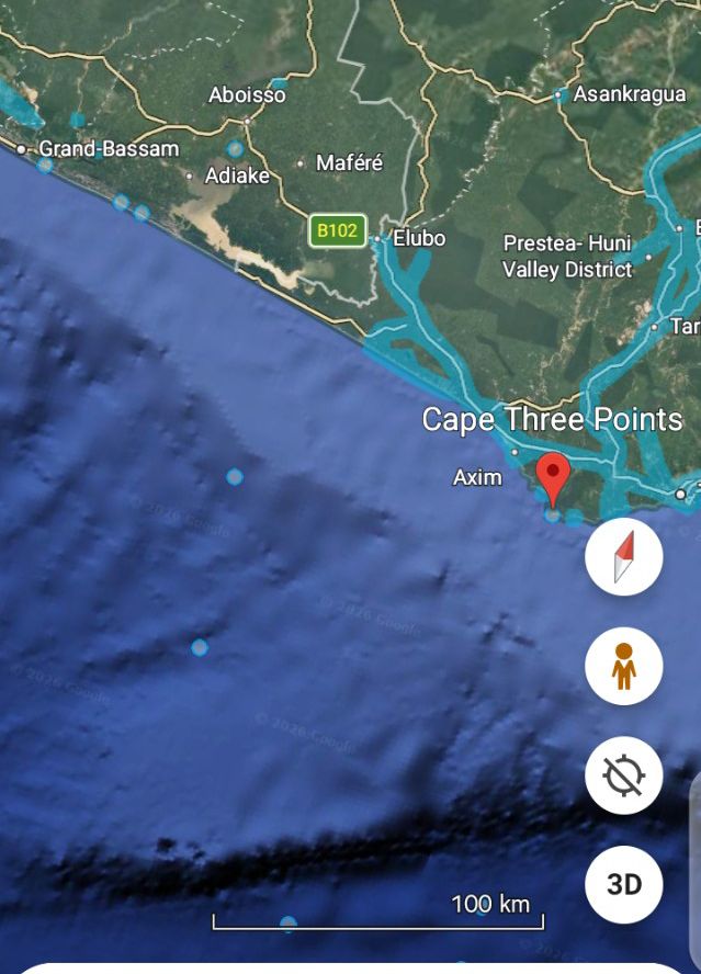
On 14 April 2026, Ghana declared the Greater Cape Three Points Marine Protected Area. It covers 703.86 square kilometres across the waters of Ahanta West and Nzema East.
The government said it would restore fish stocks, protect biodiversity and secure coastal livelihoods. Cabinet had approved it on 7 October 2025.
Diana had seen what protection could look like. In Kenya, on a glass-bottomed boat, she watched fish move over coral reefs beneath clear water.
“I was born and bred in Dixcove and have swum inside the sea for so many years,” she said. “But I have not seen inside the sea because filth and garbages have engulfed it so much that you cannot see the natural environment.”
Diana Esi Tetteh Gyaban, Queen Mother of Fishers and Fishmongers at Lower Dixcove and a member of the Management Executive Committee of Ghana’s first Marine Protected Area
Diana is the Queen Mother of Fishers and Fishmongers at Lower Dixcove. She has spent her life in the sea.
But the MPA she now helps oversee was declared before its rules were written.
The Ministry’s RTI response confirmed the management plan will not be operational until 2027. The zoning—which will determine which areas are no-take zones—has not been finalized.
Dr Evans Arizi, Chairman of the MPA Technical Advisory Committee, confirmed: “Zonation of the MPA is an ongoing activity at the moment as part of the development of the management plan for the MPA. That has not been done.”
Stephen Kankam, Deputy Director of Hen Mpoano, the NGO that supported the MPA’s technical development, was equally direct: “Ecological knowledge mapping conducted so far has informed only the delineation of the MPA boundaries, not its zonation at this stage.”
Stephen Kankam, Deputy Director of Hen Mpoano, shares his expertise during an interview In Takoradi
Ghana declared a protected area without deciding what would be protected.
The Contract That Came First
The investigation obtained the petroleum agreement for GH_WB_01 under the Right to Information Act.
The agreement names the Government of Ghana, Ghana National Petroleum Corporation, GNPC Exploration and Production Limited, and Tristar Upstream Oil & Gas Ltd.
The signed Petroleum Agreement for the GH_WB_01 Contract Area, obtained under the Right to Information Act, 2019 (Act 989), reveals that the Government of the Republic of Ghana, represented by the then Minister for Energy, Hon. Matthew Opoku Prempeh, granted Ghana National Petroleum Corporation (GNPC), GNPC Exploration and Production Limited Company (Exploreo), and Tristar Upstream Oil & Gas Ltd a contract area of approximately 1,900 square kilometres that is “bound to the south by Ghana’s coastline”—directly overlapping the coastal zone of the 703.86-square-kilometre Marine Protected Area declared in April 2026.
The agreement, signed before July 2024 and ratified by Parliament before the MPA declaration, commits the contractor to acquire and interpret 3D seismic data covering 1,200 square kilometres and drill at least one exploratory well, with a minimum expenditure of US$10 million. It is majority-operated by Tristar Upstream Oil & Gas Ltd, whose Chief Executive Deepak Balaji signed using a Planet One email address (dbalaji@planetone-group.com), holding a 76.5% participating interest during exploration that drops to 65% during development and production, with Exploreo holding 17.6% and an Indigenous Ghanaian Company holding 5.9%.
Critically, the agreement contains a stabilisation clause (Article 28) protecting the contractor from any change in Ghanaian law that “substantially and adversely affected the rights and obligations or the economic benefits” of the oil company—a clause that could be invoked because of the MPA declaration and that permits the company to take Ghana to international arbitration, where a panel could order “damages or modifications to the Agreement” to restore the company’s economic balance. The NDC government declared the MPA over an area where the previous NPP government had already signed a binding contract with an oil company. That contract is legally stronger than the MPA.
The Africa Centre for Energy Policy analysed the deal in its 2026 budget review. It said publicly available information showed “a questionable track record in upstream petroleum operations.” It questioned “the level of parliamentary oversight and due diligence undertaken before the agreement was concluded.”
The Ministry of Fisheries and Aquaculture Development was asked about the overlap and Article 28. It refused to answer, citing Sections 18 and 24 of the RTI Act.
Yet Its own MPA Management and Governance Framework acknowledges the overlap. “Potentially overlapping offshore contract areas include the Shallow Water Cape Three Points contract area, the GH_WB_01 block, and the GH_CB_05 block,” the framework states.
The Ministry documented the overlap. Then declined to discuss it.
Dr. Evans Arizi, the Chairman of the MPA Technical Advisory Committee and a marine scientist at the University of Cape Coast, acknowledged the impasse but distanced his committee from resolving it: “The situation where some oil companies still exploring oil concession around the MPA can be managed at the ministerial level. Frankly speaking, this is beyond TAC.”
The $94 Million Well
The GH_WB_01 agreement is not the only petroleum interest in the Cape Three Points marine spaWel
A December 2025 Joint Partner Committee presentation outlines a drilling campaign in the Deepwater Cape Three Points block involving Planet One Oil & Gas. It gives a 2026 budget of more than $94 million, including a 10% contingency. Regulatory approvals were scheduled for Q2 2026. Rig mobilisation for Q3. Drilling for Q4.
The presentation describes the block as “adjacent to major recent discoveries and producing fields.” It estimates potential resources of 1,039 million barrels of oil.
Planet One operates the block with a 75% participating interest. GNPC holds 15%. GOIL Upstream holds 10%.
In March 2026, Planet One announced its drilling campaign, subject to environmental impact assessments and permits. By September, the company was targeting an October spud for the Nya Gyidie-1X exploration well, pending release of the Noble Venturer rig.
When asked whether it knew of the $94 million budget when it declared the MPA, the Ministry again refused to answer, citing the same RTI exemptions.”
Two arms of government were operating in the same marine space. Neither told the other until after the declaration.
The ‘Low-Impact’ Proposal
According to the official notes from that 18 May meeting, the Petroleum Commission proposed that the TriStar block ‘should be considered under low-impact zones.
A “low-impact zone” inside a Marine Protected Area is a contradiction. The IUCN has established that “any industrial activities and infrastructural developments (e.g. mining, industrial fishing, oil and gas extraction) are not compatible with MPAs.”
Dr Steven Lindfield, the MPA Design Scientist, was more direct in his November 2023 research protocol: “Any industrial activities and infrastructural developments (e.g. mining, industrial fishing, oil and gas extraction) are not compatible with MPAs and should be excluded from such areas if they are to be considered as MPAs.”
This is not a matter of interpretation. The IUCN’s MPA Guide, the global benchmark for protected area classification, is explicit. Its assessment framework begins with a single question: “Is mining, mineral oil and/or gas prospecting or exploitation allowed?” If the answer is yes, the guide states, the site is “incompatible with conservation according to the IUCN guidelines,” and the assessment is complete. By proposing that the TriStar block be considered a “low-impact zone” within the MPA, the Petroleum Commission was proposing a category of protection that the world’s leading conservation authority defines as no protection at all.
The Fisheries Commission did not reject the proposal. The notes record only that “both parties agreed to continue technical engagements.”
The Fisheries Commission’s willingness to entertain the proposal stems from its official framework. Prof. F.K.E. Nunoo, Technical Advisor at the Fisheries Commission, explained the government’s position: “The MPA framework is intended to protect critical fish breeding and nursery grounds while still allowing selected economic activities under regulated conditions.”
Dr. Evans Arizi, Chairman of the MPA Technical Advisory Committee, was not present at that meeting. But his position on the oil overlap was unambiguous when interviewed for this investigation.
Dr. Evans Arizi, Chairman of the MPA Technical Advisory Committee and a marine scientist at the University of Cape Coast
He said the government could rescind the oil blocks entirely: “The government who gave out those places can rescind the decision not to release the place to the people any longer because the place is now being protected.” He added a condition for coexistence: “Unless oil companies can find a method and approach which is not going to be harmful to the marine life within the MPA… otherwise the method they are going to use is going to disturb the natural environment. The government should intervene to ensure that the place will be protected because the fisheries are very important.”
The Ministry’s RTI response confirms that inter-agency engagements took place in May 2026. After the declaration. After Cabinet approval.
The consultation with the Petroleum Commission did not happen before the MPA was declared.
The Science That Was Known to Be Flawed
The MPA’s boundaries were drawn using data its own design scientist had already identified as unreliable.
Lindfield’s November 2023 protocol was blunt: “During the scoping trip, it has become obvious that the existing bathymetry that was used to identify the location of the six core MPA sites is flawed. Areas that were proposed as coming up very shallow are actually deep (37 m depth) and these bathymetric data cannot be trusted.”
He said new maps would be needed “if MPA zoning is to protect biologically important and representative areas of habitat.”
The Ministry’s RTI response said the management plan framework was “at an intermediate stage of approval.” It cited Section 22 of the RTI Act to defer access.
The Enforcement Gap
The Ministry’s RTI response put the 2026 allocation for fisheries Monitoring, Control and Surveillance at GH¢8,068,226. Across Ghana’s entire marine space. Including the 703-square-kilometre MPA.
The division has 33 staff, working alongside other Fisheries Enforcement Unit personnel.
The figure does not establish that only 33 people enforce the MPA. But it shows the scale of the national system.
An analysis of Ghana’s Exclusive Economic Zone between 1 May and 1 September 2026 recorded 72 vessels with 17,336 hours of fishing activity. Eighteen trawlers accounted for 8,192 hours.
The MPA was not available as a distinct operational boundary on Global Fishing Watch at the time of assessment. Independent researchers could not isolate fishing activity within the protected area from activity elsewhere.
This is not merely a transparency inconvenience. A 2025 study published in the journal Science used Global Fishing Watch’s satellite data to map industrial fishing in coastal marine protected areas worldwide. It found that a significant portion of fishing activity inside MPAs is “untracked”—occurring on vessels that do not broadcast their location. By failing to operationalize the MPA boundary on Global Fishing Watch, Ghana has ensured that any industrial fishing inside its protected area would fall into this untracked category, invisible to independent scrutiny.
The Environmental Justice Foundation’s February 2026 report, Breaking the Vicious Circle, found that 53% to 60% of trawler landings consisted of bycatch. 96% of chub mackerel and 97% of round sardinella were below the legal minimum size. The report found 94% of surveyed fishers reported declining catches. 87% said incomes had fallen.
Kankam argued trawlers should not be inside the MPA. He pointed to the Inshore Exclusion Zone extension to 12 nautical miles, while the MPA ends at six.
“The trawlers do not even have the right to fish closer to the MPA,” he said.
But the absence of proof that a trawler entered the MPA does not remove the enforcement challenge. Illegal fishing in surrounding waters still undermines stock recovery.
The government’s own 2026 Budget Estimates, overseen by
The Minister of Fisheries and Aquaculture Development, Emelia Arthur , reveal the stark reality behind the enforcement gap: the Ministry acknowledges that its law enforcement programme is crippled by “resistance or non-compliance to fisheries regulations by fishers, high cost of patrols, lack of patrol boats, limited operations in the inland fisheries due to inadequate staff and proliferation of illegal fishing methods.
The People Paying for Declining Catches
Dr Vanessa Ofoliorkor Blessyn’s 2025 MPhil thesis at the University of Cape Coast found that seven of eight communities near the MPA had high marine-resource dependency. Scores ranged from 7.12 to 8.22 on a scale of 11.
Fishers in Dixcove reported spending GH¢10,000 to fish and earning GH¢4,000.
A fisher in Aketekyi: “At first, we could harvest five containers easily, but ever since light fishing became rampant, we can cover a very long distance for 10 days, and we won’t get even two containers.”
Artisanal fishers and community members gather on the beach in Dixcove to sort their catch. The community is one of 21 coastal settlements adjacent to the Greater Cape Three Points Marine Protected Area.
A fisher from Akonu: “Implementing the MPA will bring about hunger in the community. As it is closed season now, there are fish in the sea, but we are not supposed to go fishing, and we are hungry, so if the MPA comes, it is going to do the same, and we will face hunger.”
Women bear the brunt. A woman from Agyan: “In difficult times, we, the ladies, suffer more. When it happens, there is no money, so when the kid goes to their dad for anything, he tends to direct them to us to cater or provide for the needs of the child… whether I have or not, I will have to provide for the kids, so in times of difficulty, we, the ladies, suffer a lot.”
The Ministry’s RTI response identifies alternative-livelihood measures. It does not state how many people have received them, how much funding has been committed, or whether they offset the economic pressures.
Galamsey Is Carrying Pollution to the Sea
Kankam explained the ecological connection between the Cape Three Points forest reserve and the sea. Leaves fall. Rain washes them into rivers and coastal waters. They break down. They become food for fish.
“Unfortunately, illegal mining is happening in the forest,” he said. “That means potential pollutants from the illegal mining sites are washed down into the ocean. And even outside the forest there are streams and rivers where the illegal mining activities are happening and all of that is washing pollutants into the MPA area.”
Diana has seen the change. The sea has turned brown and dark. She attributes it to galamsey.
She recalled visiting Princess Ahona. Fishers were pulling nets near the beach. Those helping expected a catch. The nets came back empty.
“They told us that it is because of the use of those hard metals they use at illegal gold mining sites,” she said.
Dr Sabina Abuga’s 2025 MPhil thesis reported nitrate concentrations of 8.27 milligrams per litre in the MPA area. The optimal level is 1.0. Biochemical oxygen demand was 5.19 milligrams per litre, above the 2 milligrams-per-litre threshold for healthy ecosystems.
Arizi said the Fisheries Minister took action after the committee raised concerns. Arrests were made. Suspects were sent to Sekondi to be remanded.
Kankam said enforcement had been inconsistent. He called for permanent protection camps.
Promises, Participation and Trust
Brewe Acker, a 33-year-old fisher at Egyambra, said his community felt excluded.
“It appears Egyambra is cut away from other fishing communities because there are so many development projects we are excluded, we don’t benefit from it and we don’t even hear of them happening here,” he said.
He said residents heard GNPC would construct their road six years ago. The work was not done. In the rainy season, drivers charge up to three times the normal fare. Sick people and pregnant women suffer.
A vehicle navigates a severely degraded, muddy road leading to Egyambra, one of the coastal communities within the Greater Cape Three Points Marine Protected Area, while a man attempts to make a portion of it passable.
“We know there is an oil company extracting oil from the sea near Egyambra here but we don’t hear any beneficial thing in terms of development projects from Ghana National Petroleum Commission, GNPC,” he said.
Diana questioned the reach of oil company scholarships. She named Tullow Energy, Aker Energy and Pecan. She said the scholarships were too few.
At Miemia, Chief Fisherman Nana Kwame Asabre identified poor roads and unreliable telecommunications as barriers.
“If they want the implementation of the MPA to be successful and sustainable then they should come and construct our road network and improve the telecommunication network,” he said.
Nana Kwame Asabre, the Chief Fisherman of Miemia, stands outside a community building.
The Ministry said more than 7,000 stakeholders participated in consultations. The engagement records identify 3,639 participants across 12 stakeholder engagements between 2023 and 2024. Many attended more than one event.
Blessyn’s thesis found 38% of community members surveyed were unaware of the MPA.
A fisher in Akwidaa said: “The Government came, did their research, and concluded that this area would hold the MPA without consulting us.”
Allegations of Corruption
Aunty Afua, Deputy Queen Mother of Fishers at Miemia, alleged that task-force members accepted bribes.
“The members of the taskforce come and arrest these illegal fishers and collect bribes from them and let them go and continue their illegal activities,” she said.
She said officers should seize equipment instead of taking money.
The allegations have not been independently verified. But they warrant a response from enforcement bodies.
A fisher from Busua: “The big boats will still find ways to fish while we, the small ones, are left to suffer.”
A fisher from Aketekyi: “Some time ago, the Minister called us to Accra to discuss why the light should be banned, but still, the light is being used. The big men have the boats, so they don’t stop it.”
The 30×30 Integrity Question
Ghana has promised to protect 30% of its coastal and marine zones by 2030. The Ministry’s RTI response put existing designated protected areas at approximately 0.40% of its Exclusive Economic Zone.
The MPA is a start. It is not nearly enough.
The Coral Triangle Oil and Gas Threat Assessment, released at CBD COP16, found that 16% of protected areas overlap with oil and gas blocks.
Ghana’s MPA is not an isolated case. A 2026 analysis by the Marine Conservation Institute applied the IUCN’s MPA Guide to the world’s 100 largest marine protected areas. It found that roughly a quarter were unimplemented, a third were “incompatible with the conservation of nature,” and only 2.6% of the ocean was implemented and highly or fully protected. The “paper park” is not a Ghanaian anomaly; it is a global epidemic.
These failures are not unique to Ghana. A 2025 UN Environment Programme workshop on the global 30×30 target identified the “persistent challenges” that plague marine protection worldwide: “limited political will, fragmented legal frameworks, insufficient financing, weak management and enforcement, and gaps in monitoring and data-sharing.” Every one of these failures is present in Ghana’s MPA: a management plan delayed by political processes, a legal conflict with an oil contract, an enforcement budget of just GH¢8 million for the entire coast, and a boundary that is invisible to global monitoring platforms.
This establishes a global pattern: 30×30 targets are being met on paper while the actual protection is compromised by industrial extraction. 80 MPAs are completely covered by oil and gas blocks.
Ghana’s MPA raises the same question: is this protection, or is it accounting?
Lindfield’s research protocol distinguished between a protected area whose primary purpose is biodiversity conservation and an area-based measure focused mainly on fisheries management. The final objectives and rules matter when assessing whether the designation meets international standards.
The government should publish the final management plan, clearly identify no-take zones, explain the treatment of petroleum agreements, and provide verifiable data on enforcement and ecological recovery.
Kankam called for a comprehensive Marine Spatial Plan for the entire marine area.
“All the stakeholders—government, CSOs, traditional authorities, private sector, local communities—that have a role to play in successfully implementing the MPA should come to the table in a partnership model that could lay out the roles and responsibilities and have concerted and coordinated action,” he said.
The Ministry’s framework refers to the national MarEcoplan Project, which is intended to integrate marine spatial-planning compatibility checks into environmental approvals alongside the Environmental Protection Agency and the Land Use and Spatial Planning Authority.
That is a potential route towards better coordination. But a planning process will have limited value if major decisions about petroleum blocks and protected areas are made without transparent assessment of their spatial and ecological implications.
Model or Warning?
Diana returned from Kenya and Tanzania with examples of what the MPA could become. Clean beaches. Community enterprises. Seaweed products. Jobs for young people.
“They educated us that without community engagements they wouldn’t have succeeded and made achievements in terms of the implementation of their MPA,” she said. “What really helped them was transparency and accountability for the community members including fishmongers, fishermen, youth and elders, chiefs.”
She wants fishers to stop illegal practices.
“If we continue to resort to illegal fishing including dynamite, the use of DDT and light fishing to destroy the sea and you will go to the sea and you do not get the fish what work will we do?” she asked.
Diana Esi Tetteh Gyaban, Queen Mother of Fishers at Lower Dixcove and an MPA committee member (center) stands with colleagues under the palm trees during a field visit along the coastline at Egyambra
But fishers cannot enforce conservation alone. Industrial operators, illegal miners and public institutions operate under different powers and obligations.
The government must complete the management plan. It must publish the zoning. It must clarify how Article 28 will be reconciled with conservation objectives. It must verify the geographic relationship between the MPA and GH_WB_01. It must explain the status and location of Nya Gyidie-1X.
It must disclose the enforcement resources assigned to the MPA. It must make boundary data available for independent monitoring. It must show how water-quality testing and action against galamsey will be sustained.
And it must publish evidence of the support promised to coastal communities.
The investigation has not established that the MPA is already a failure. It has established that the questions remain unanswered.
Diana has made her commitment. She sits on the Management Executive Committee. She will stop buying fish caught through light fishing. She will educate her community.
But she cannot do it alone.
“The sea belongs to us,” she said. “If we fail to accept the MPA and they do not do the MPA for us to become sustainable, I as fish processor and you the fishers will suffer.”
Ghana’s first Marine Protected Area faces its defining test. Its future depends not on the April 2026 announcement. It depends on the rules, funding, scientific evidence and public accountability that follow.
The government declared the protected area. It must now prove the protection is real.
This story was produced with support from Internews’ Earth Journalism Network.